
To register a farm with its SIGPAC plots, you first create the farm (the holding) and then, for each crop, you identify its plots on the map: by selecting the SIGPAC enclosure with a click, by searching for it by its code (province, municipality, polygon, parcel and enclosure) or by drawing the plot by hand. Once the enclosures are linked, the area, the farm logbook and the irrigation and fertilisation calculations are all based on the real plot.
Orcelis’s screens are in Spanish; button and menu names are shown as they appear in the app.
What a SIGPAC enclosure is
SIGPAC (Sistema de Información Geográfica de Parcelas Agrícolas, Spain’s Land Parcel Identification System) is the official map base used in Spain to identify agricultural plots for Common Agricultural Policy (CAP) payments. Each parcel is divided into enclosures (recintos): continuous areas with a single land use (for example, fruit trees, arable land or pasture).
Each enclosure has a code made up of seven parts:
| Part | What it identifies |
|---|---|
| Province (Provincia) | The province code. |
| Municipality (Municipio) | The municipal district code. |
| Aggregate (Agregado) | A subdivision of the municipality; usually 0. |
| Zone (Zona) | A further subdivision; usually 0. |
| Polygon (Polígono) | A group of parcels within the municipality. |
| Parcel (Parcela) | The parcel within the polygon. |
| Enclosure (Recinto) | The part of the parcel with a single land use. |
You will find your enclosure codes in your CAP declaration or in the official SIGPAC viewer. If you don’t have them to hand, you can locate the plot directly on the map.
Why it pays to link the enclosures
- Farm logbook: operations are recorded against identified plots.
- Real area: you know how many hectares each crop covers without measuring by hand.
- Environmental constraints: the location tells you, for example, whether the plot lies in a nitrate vulnerable zone.
- Treatments by plot: you can prescribe a treatment only for the enclosures that need it.
Step by step
- Create the farm. In Explotaciones (Farms), click «+ Añadir explotación» (Add farm) and type the Nombre de la explotación (farm name). It is the only required field; the owner and the area are optional.
- Fill in the official details. Under «+ Más datos (opcional)» (More details) you will find the tax ID (NIF), the address, the SIEX code, the REA number and the autonomous community. You don’t need them to get started, but you do need them for the farm logbook.
- Move on to the crop. Click «Crear y añadir cultivo →» (Create and add crop). The map opens so you can mark that crop’s plots.
- Find the area. Use the search box «Buscar pueblo, zona o dirección…» (search for a town, area or address) or the «Ir a mi ubicación» (go to my location) button.
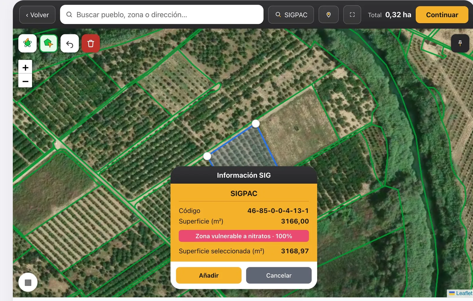
- Select the SIGPAC enclosure. With the Seleccionar recinto SIGPAC tool, hover over the enclosure and click. If you know the code, click the SIGPAC button in the top bar, fill it in and click «Buscar recinto» (find enclosure).
- Or draw the plot by hand. Click on each corner and close the shape on the first point. Orcelis automatically detects the SIGPAC enclosures underneath; untick the ones you don’t want in the «Parcelas» panel.
- Add each plot. In the «Información SIG» panel, with the area calculated, click «Añadir» (Add). Repeat for every plot of the crop and click «Continuar» (Continue).
- Finish registering the crop. Choose the crop type and variety, the planting and irrigation details, review the summary and click «Dar de alta el cultivo» (Register crop).
After registering
In the last step, Orcelis shows you whether the plot lies in a nitrate vulnerable zone and how accurate the calculation is with the data you have entered. The enclosures are stored in the crop record, under the Datos del cultivo (crop data) tab, in the Parcelas SIGPAC block. From there you can add another one with «+ Nuevo recinto» (new enclosure) or, if the plot was drawn by hand, click «Detectar recintos SIGPAC» (detect SIGPAC enclosures) so that Orcelis matches the drawing against SIGPAC and adds the enclosures it covers.
For woody crops, Orcelis calculates the irrigated area from number of trees × planting spacing, not from the map. If the two differ by more than 25%, it warns you with «No cuadran…» (they don’t match) so you can check the number of trees or the spacing.
Frequently asked questions
Where can I find the SIGPAC code of my plot?
In your CAP declaration or in the official SIGPAC viewer. If you don’t have it, locate the plot on the Orcelis map and select the enclosure with a click: the code is assigned automatically.
My plot doesn’t match a SIGPAC enclosure. What should I do?
Draw it by hand on the map. Orcelis detects the SIGPAC enclosures underneath the drawing and you can untick the ones that don’t belong.
It won’t let me move on from the map
You need at least one plot added. Check that you clicked «Añadir» in the «Información SIG» panel before «Continuar».